![](/images/other/stat-length.png)
![Excursión Senderismo San Cristóbal de La Laguna - Punta de Hidalgo - Batan de Abajo - Photo](https://media.geolcdn.com/t/1900/400/ext.pjpeg?maxdim=2&url=https%3A%2F%2Fservices.sitytrail.com%2FGeolivesWS%2FDownloadMedia.ashx%3FTrailID%3D384279%26Media%3Dfix__20150101180529.jpg)
Punta de Hidalgo - Batan de Abajo
karawatsj
Usuario
![Longitud](/images/other/stat-length.png)
Longitud
14,4 km
![Altitud máxima](https://static1.geolcdn.com/siteimages/upload/files/1508320355ic_sort_altitude_max_24dp.png)
Altitud máxima
597 m
![Desnivel positivo](https://static1.geolcdn.com/siteimages/upload/files/1508320355ic_sort_den_pos_24dp.png)
Desnivel positivo
844 m
![Km-Effort](/images/other/stat-length.png)
Km-Effort
26 km
![Altitud mínima](https://static1.geolcdn.com/siteimages/upload/files/1508320355ic_sort_altitude_min_24dp.png)
Altitud mínima
14 m
![Desnivel negativo](https://static1.geolcdn.com/siteimages/upload/files/1508320355ic_sort_den_neg_24dp.png)
Desnivel negativo
851 m
![Boucle](https://static1.geolcdn.com/siteimages/upload/files/16400158638029165_repeat_loop_refresh_sync_direction_icon.png)
Boucle
Sí
Fecha de creación :
2016-03-09 00:00:00.0
Última modificación :
2016-03-09 00:00:00.0
![Senderismo](https://static1.geolcdn.com/sitytour/trail-icons/101.png)
5h49
Dificultad : Desconocido
![Escanee este código QR para abrir la excursión en la aplicación SityTrail](https://capi.geolives.com/qq0zvz2zws4bq2lad0pu/sitytour/trails/384279/qr.png?size=200)
Aplicación GPS de excursión GRATIS
A propósito
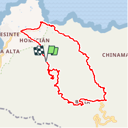
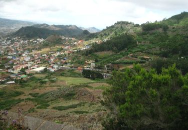
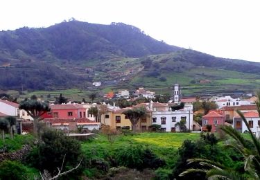
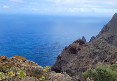
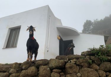
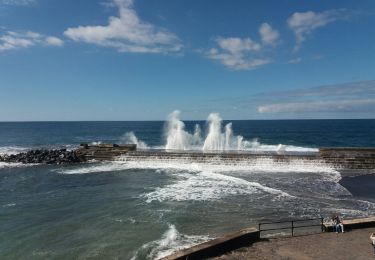
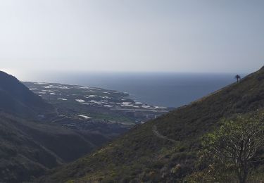
Ruta Senderismo de 14,4 km a descubrir en Canarias, Santa Cruz de Tenerife, San Cristóbal de La Laguna. Esta ruta ha sido propuesta por karawatsj.
Descripción
Zeer gevarieerd zeer mooie tocht. Prachtige zichten.
Zaklamp meenemen voor tunnels.
POI3 en 4 verkeerd gelopen.
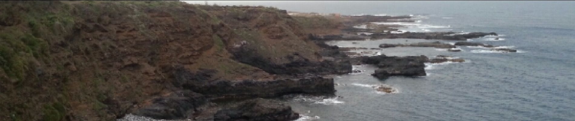
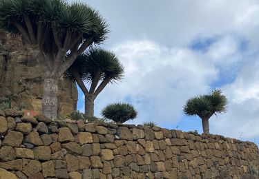
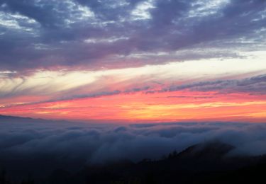
Localización
País:
Spain
Región :
Canarias
Departamento/provincia :
Santa Cruz de Tenerife
Municipio :
San Cristóbal de La Laguna
Localidad:
Unknown
Salida:(Dec)
Salida:(UTM)
371230 ; 3159921 (28R) N.
Comentarios
Excursiones cerca
![Excursión Senderismo San Cristóbal de La Laguna - Massif de l'Anaga El Batan Chinamada - Photo](https://media.geolcdn.com/t/375/260/bf287400-cf63-4351-bbc9-dbe9aba0fa64.jpg&format=jpg&maxdim=2)
![Senderismo Senderismo](https://static1.geolcdn.com/sitytour/trail-icons/101.png)
Massif de l'Anaga El Batan Chinamada
Senderismo
Muy difícil
San Cristóbal de La Laguna,
Canarias,
Santa Cruz de Tenerife,
Spain
![](/images/other/stat-length.png)
10,8 km | 21 km-effort
4h 45min
![](https://static1.geolcdn.com/siteimages/upload/files/16400158638029165_repeat_loop_refresh_sync_direction_icon.png)
Sí
![Excursión A pie Tegueste - El bosque de los enigmas - Photo](https://media.geolcdn.com/t/375/260/1a03fed7-fb28-4a0e-9d0f-13adda6bed3b.jpeg&format=jpg&maxdim=2)
![A pie A pie](https://static1.geolcdn.com/sitytour/trail-icons/100.png)
El bosque de los enigmas
A pie
Fácil
(1)
Tegueste,
Canarias,
Santa Cruz de Tenerife,
Spain
![](/images/other/stat-length.png)
4,5 km | 6,7 km-effort
1h 31min
![](https://static1.geolcdn.com/siteimages/upload/files/16400158638029165_repeat_loop_refresh_sync_direction_icon.png)
Sí
![Excursión A pie Tegueste - SL-TG 03 Las Canteras-Las Toscas - Photo](https://media.geolcdn.com/t/375/260/9b02a4e1-6549-4943-9eb8-9ef13f2363ff.jpeg&format=jpg&maxdim=2)
![A pie A pie](https://static1.geolcdn.com/sitytour/trail-icons/100.png)
SL-TG 03 Las Canteras-Las Toscas
A pie
Fácil
Tegueste,
Canarias,
Santa Cruz de Tenerife,
Spain
![](/images/other/stat-length.png)
6,4 km | 9,8 km-effort
2h 13min
![](https://static1.geolcdn.com/siteimages/upload/files/16400158638029165_repeat_loop_refresh_sync_direction_icon.png)
No
![Excursión A pie San Cristóbal de La Laguna - ES-SL-TG 01 Tegueste-Bajamar - Photo](https://media.geolcdn.com/t/375/260/65f44273-f2cc-400e-98ab-6e6e24660cd8.jpeg&format=jpg&maxdim=2)
![A pie A pie](https://static1.geolcdn.com/sitytour/trail-icons/100.png)
ES-SL-TG 01 Tegueste-Bajamar
A pie
Fácil
San Cristóbal de La Laguna,
Canarias,
Santa Cruz de Tenerife,
Spain
![](/images/other/stat-length.png)
8,9 km | 17,5 km-effort
3h 59min
![](https://static1.geolcdn.com/siteimages/upload/files/16400158638029165_repeat_loop_refresh_sync_direction_icon.png)
No
![Excursión Senderismo San Cristóbal de La Laguna - Punta del Hidalgo - Chinamada - Photo](https://media.geolcdn.com/t/375/260/2c9fb02f-c984-4854-86fb-fc5721d63a53.jpg&format=jpg&maxdim=2)
![Senderismo Senderismo](https://static1.geolcdn.com/sitytour/trail-icons/101.png)
Punta del Hidalgo - Chinamada
Senderismo
Medio
San Cristóbal de La Laguna,
Canarias,
Santa Cruz de Tenerife,
Spain
![](/images/other/stat-length.png)
10,9 km | 20 km-effort
3h 30min
![](https://static1.geolcdn.com/siteimages/upload/files/16400158638029165_repeat_loop_refresh_sync_direction_icon.png)
Sí
![Excursión Senderismo San Cristóbal de La Laguna - Las Carbonaras Chimada AR - Photo](https://media.geolcdn.com/t/375/260/b1c626c3-3510-4ce3-890e-282b82838da6.jpg&format=jpg&maxdim=2)
![Senderismo Senderismo](https://static1.geolcdn.com/sitytour/trail-icons/101.png)
Las Carbonaras Chimada AR
Senderismo
Fácil
(1)
San Cristóbal de La Laguna,
Canarias,
Santa Cruz de Tenerife,
Spain
![](/images/other/stat-length.png)
5,7 km | 8,8 km-effort
1h 35min
![](https://static1.geolcdn.com/siteimages/upload/files/16400158638029165_repeat_loop_refresh_sync_direction_icon.png)
Sí
![Excursión Senderismo San Cristóbal de La Laguna - Cruz del Carmen al Mar Bajamar - Photo](https://media.geolcdn.com/t/375/260/ext.jpg?maxdim=2&url=https%3A%2F%2Fservices.sitytrail.com%2FGeolivesWS%2FDownloadMedia.ashx%3FTrailID%3D908007%26Media%3Dfix__20180218155348.jpg)
![Senderismo Senderismo](https://static1.geolcdn.com/sitytour/trail-icons/101.png)
Cruz del Carmen al Mar Bajamar
Senderismo
Fácil
San Cristóbal de La Laguna,
Canarias,
Santa Cruz de Tenerife,
Spain
![](/images/other/stat-length.png)
11,4 km | 15,6 km-effort
3h 4min
![](https://static1.geolcdn.com/siteimages/upload/files/16400158638029165_repeat_loop_refresh_sync_direction_icon.png)
No
![Excursión Senderismo San Cristóbal de La Laguna - forêt primaire de l'Anaga - Photo](https://media.geolcdn.com/t/375/260/ext.jpg?maxdim=2&url=https%3A%2F%2Fservices.sitytrail.com%2FGeolivesWS%2FDownloadMedia.ashx%3FTrailID%3D422872%26Media%3D20150511145711.jpg)
![Senderismo Senderismo](https://static1.geolcdn.com/sitytour/trail-icons/101.png)
forêt primaire de l'Anaga
Senderismo
Fácil
(2)
San Cristóbal de La Laguna,
Canarias,
Santa Cruz de Tenerife,
Spain
![](/images/other/stat-length.png)
9,4 km | 13,4 km-effort
3h 23min
![](https://static1.geolcdn.com/siteimages/upload/files/16400158638029165_repeat_loop_refresh_sync_direction_icon.png)
Sí
![Excursión Senderismo Tegueste - Cruz del Carmen - Bajamar PR-TF12 - Photo](https://media.geolcdn.com/t/375/260/869fb28d-8541-4ec9-95a5-44120c6d68b4.jpg&format=jpg&maxdim=2)
![Senderismo Senderismo](https://static1.geolcdn.com/sitytour/trail-icons/101.png)
Cruz del Carmen - Bajamar PR-TF12
Senderismo
Difícil
Tegueste,
Canarias,
Santa Cruz de Tenerife,
Spain
![](/images/other/stat-length.png)
9,3 km | 12,8 km-effort
4h 44min
![](https://static1.geolcdn.com/siteimages/upload/files/16400158638029165_repeat_loop_refresh_sync_direction_icon.png)
No